Got a Coupon
Product Details and Options
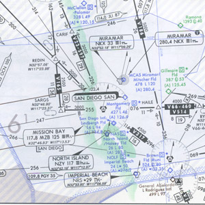
Enroute Low Altitude Charts

IFR - nacoelus - 2488
Price: $6.99
No InventoryIFR Enroute Low Altitude Charts provide aeronautical information for navigation under instrument flight rules below 18,000 feet MSL. This four-color chart series includes:
- Airways
- Limits of controlled airspace
- VHF radio aids to navigation (frequency, identification, channel, geographic coordinates)
- Airports that have an Instrument Approach Procedure or a minimum 3000' hard surface runway
- Off Route Obstruction Clearance Altitudes (OROCA)
- Reporting points
- Special use airspace areas
- Military Training Routes
Area Charts, which show congested terminal areas at a large scale, are included with subscriptions to any conterminous U.S. Set Low (Full set, East or West sets). Chart L-28 covers the Washington-Boston corridor at a scale similar to an Area Chart. Charts are revised every 56 days.
| Chart Type | Nautical miles/inch |
|---|---|
| Instrument Flight Rules (IFR) Enroute Low Altitude Chart for the Conterminous U.S. | Varies from 5 to 20 |
|
|
|