Got a Coupon
Product Details and Options
U.S. Terminal

VFR - nacotac - 2475
Price: $6.99
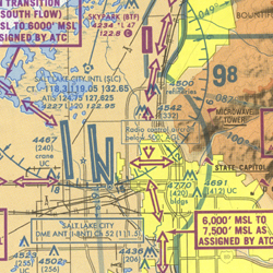
No Inventory Terminal Aeronautical Charts depict the airspace designated as Class B airspace. The information found on these charts, while similar to that found on Sectional Charts, is shown in much more detail because of the larger scale. These charts should be used by pilots intending to operate from airfields within or near Class B airspace or Class C airspace. Coverage of Terminal Area Charts are indicated by shaded boxes on the Sectional Chart index.
*NOTE: Charted VFR Flyway Planning Charts are printed on the backs of selected Terminal Area Charts.
Â
Â
| Chart Type | Nautical miles/inch | Nautical miles/cm | Scale |
|---|---|---|---|
| Terminal Area Charts | 3.43 | 1.35 | 1:250,000 |
Â
|
|